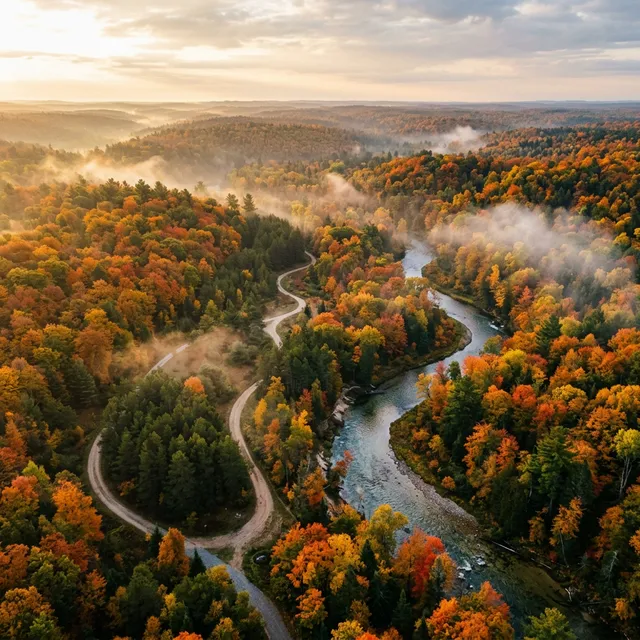
Michigan Public Land Hunting: State Forests, National Forests, Game Areas & Wetland Wonders
Navigate Michigan's 7.4 million acres of public hunting land — from the massive Upper Peninsula state forests to the southern game areas and managed waterfowl marshes.
TL;DR — Key Takeaways
- Michigan has 7.4 million acres of public hunting land — one of the largest systems east of the Mississippi.
- State forests total 4.6 million acres across both peninsulas, with the Au Sable (940K) and Lake Superior (896K) being the largest.
- Three national forests — Huron-Manistee, Ottawa, and Hiawatha — add nearly 3 million more acres.
- The 7 "Wetland Wonders" are premier managed waterfowl areas in the southern LP, covering 29,000+ acres.
- The DNR's free Mi-HUNT online tool is essential for scouting public land boundaries, cover types, and access points.
- No special permits are needed for most public land — your base license grants access to state and national forests.
In This Guide 8 sections
- Michigan's Public Land Advantage
- State Forests — The Backbone of Michigan Hunting
- National Forests — Nearly 3 Million More Acres
- State Game Areas — Managed for Wildlife
- The 7 Wetland Wonders — Michigan's Premier Waterfowl Destinations
- The Mi-HUNT Tool — Your Essential Scouting Companion
- Public Land Strategies — How to Find Success
- Michigan Public Land Hunting FAQ
Michigan's Public Land Advantage
Michigan is one of the best public-land hunting states in America — and it's not even close for the eastern half of the country. With 7.4 million acres of publicly accessible hunting land, Michigan offers more free-access hunting area than the majority of eastern states combined.
This massive public land system exists because of Michigan's history. The logging era of the late 1800s and early 1900s stripped vast tracts of forest across both peninsulas. When the timber companies moved on, they left behind millions of acres of cutover land that reverted to state ownership for unpaid taxes. The Michigan Department of Natural Resources (DNR) has since managed these lands for wildlife habitat, timber, recreation, and hunting — creating one of the most hunter-friendly public land systems in the nation.
For hunters — especially those from states with limited public access like Iowa, Illinois, or Kentucky — Michigan's public land is a revelation. You can hunt vast state forests, national forests, state game areas, and wildlife management areas without paying access fees, joining lease clubs, or obtaining special permits (with a few exceptions for managed hunt areas).
State Forests — The Backbone of Michigan Hunting
Michigan's state forest system is the largest in the nation, encompassing approximately 4.6 million acres across both peninsulas. These forests are managed by the DNR for multiple uses including wildlife habitat, timber harvest, recreation, and hunting.
Major State Forests
| State Forest | Acres | Location | Primary Game Species |
|---|---|---|---|
| Au Sable State Forest | 940,000+ | Northern LP | Deer, grouse, woodcock, turkey |
| Lake Superior State Forest | 896,000 | Eastern UP | Deer, bear, grouse, snowshoe hare |
| Escanaba State Forest | 530,000+ | Central UP | Deer, bear, grouse |
| Pere Marquette State Forest | 428,000 | Northwest LP | Deer, grouse, turkey, woodcock |
| Mackinaw State Forest | 721,000 | Northern LP/UP | Deer, bear, grouse, woodcock |
| Pigeon River Country State Forest | 106,000 | Northern LP | Deer, elk, grouse, turkey |
| Copper Country State Forest | 340,000 | Western UP | Deer, bear, grouse |
| Houghton Lake State Forest | 245,000 | Central LP | Deer, turkey, small game |
Highlight: Au Sable State Forest
The Au Sable State Forest is Michigan's largest and arguably its most storied hunting destination. Spanning over 940,000 acres across the northern Lower Peninsula, it's named for the Au Sable River — Michigan's most famous trout stream.
What makes Au Sable exceptional for hunters:
- Enormous size — At nearly 1 million acres, you could hunt a different spot every day for years and never repeat.
- Diverse habitat — A mix of jack pine barrens, northern hardwoods, cedar swamps, and pine plantations creates ideal edge habitat for whitetails.
- Legendary grouse country — The aspen stands throughout Au Sable are among the best ruffed grouse habitat in Michigan.
- Access network — Hundreds of miles of two-track roads provide vehicle access deep into the forest.
- Relatively light pressure — Despite its size, the northern portions of Au Sable see far fewer hunters than southern Michigan game areas.
Highlight: Pigeon River Country State Forest
At 106,000 acres, Pigeon River Country is smaller than the mega-forests but packs an outsized punch. It's home to Michigan's free-ranging elk herd — the only wild elk population east of the Mississippi — and offers some of the wildest, most remote terrain in the Lower Peninsula.
- Elk viewing and hunting — Even if you don't draw an elk tag, Pigeon River Country is the best place in Michigan to see and hear wild elk bugling in September.
- Trophy deer — Lower hunting pressure and diverse habitat produce quality bucks.
- Restricted vehicle access — Much of Pigeon River Country has limited motorized access, which reduces crowding and pressure.
National Forests — Nearly 3 Million More Acres
Michigan's three national forests add approximately 2.9 million acres to the state's public hunting portfolio. These are managed by the U.S. Forest Service and are open to hunting under Michigan state regulations.
| National Forest | Acres | Location | Key Features |
|---|---|---|---|
| Huron-Manistee National Forest | 1,000,000 | Northern LP | Michigan's largest NF; pine plantations, hardwoods, river corridors; excellent deer and grouse |
| Ottawa National Forest | 994,000 | Western UP | Extremely remote old-growth areas; rugged terrain; bear, deer, grouse |
| Hiawatha National Forest | 894,000 | Central/Eastern UP | Diverse habitat from Lake Michigan to Lake Superior; deer, bear, grouse, woodcock |
What Sets National Forest Hunting Apart
National forests differ from state forests in several important ways:
- Dispersed camping — You can camp for free almost anywhere in a national forest (with some restrictions). This makes extended backcountry hunts practical and affordable.
- Longer access roads — National forests often have deeper road networks than state forests, allowing access to truly remote areas.
- Federal regulations apply — While hunting is governed by Michigan state law, some federal rules (like campfire restrictions during fire season) also apply.
- Less active management — National forests generally have less intensive habitat management than state game areas, meaning the hunting is more "wild" but potentially less productive per acre.
State Game Areas — Managed for Wildlife
Michigan's state game areas (SGAs) encompass approximately 688,000 acres across the state. Unlike state forests, which are managed for multiple uses, SGAs are specifically managed for wildlife habitat and hunting opportunity. Many SGAs feature:
- Active habitat management (food plots, mowing, timber harvest)
- Designated parking areas and hunter access trails
- Managed pheasant release programs (southern LP)
- Waterfowl flooding impoundments
- Designated archery-only or shotgun-only zones
Top State Game Areas by Species
| Game Area | County | Acres | Best Species |
|---|---|---|---|
| Allegan SGA | Allegan | 51,250 | Turkey, deer, waterfowl, pheasant |
| Barry SGA | Barry | 16,692 | Deer, rabbit, grouse, turkey |
| Flat River SGA | Ionia/Montcalm | 11,235 | Deer, turkey, woodcock |
| Deford SGA | Sanilac/Tuscola | 10,390 | Grouse, woodcock, turkey, deer |
| Shiawassee River SGA | Saginaw | 10,000 | Waterfowl, deer, turkey |
| Lapeer SGA | Lapeer | 7,800 | Deer, turkey, pheasant, rabbit |
| Holly Recreation Area | Oakland | 8,000+ | Turkey, deer, small game |
| Sharonville SGA | Washtenaw/Jackson | 3,900 | Turkey, deer, pheasant |
| Rose Lake Wildlife Research Area | Clinton/Shiawassee | 3,600 | Turkey, pheasant, deer, woodcock |
| Waterloo Recreation Area | Jackson/Washtenaw | 20,000+ | Deer, turkey, small game |
Pheasant Release Program
Michigan's DNR conducts an active pheasant release program on select southern LP game areas. During the regular pheasant season, rooster pheasants are released weekly at designated locations. To participate:
- Pheasant license required — $25 for hunting pheasant on public land and Hunting Access Program (HAP) private land.
- Release schedule — The DNR posts weekly release schedules on its pheasant page.
- Top release sites — Rose Lake, Erie, Lapeer, Pointe Mouillee, Crow Island, Cornish, Dansville, and St. Johns Marsh.
The 7 Wetland Wonders — Michigan's Premier Waterfowl Destinations
Michigan designates seven Managed Waterfowl Hunting Areas (MWHAs) as "Wetland Wonders" — premier marshes and flooded agricultural areas specifically maintained for waterfowl hunting. These sites total nearly 29,000 acres and represent some of the best public waterfowl hunting in the Great Lakes region.
| Wetland Wonder | County | Acres | Managed Habitat | Primary Species |
|---|---|---|---|---|
| Pointe Mouillee SGA | Monroe/Wayne | 4,040 | Freshwater marsh, Lake Erie shore | Ducks, geese (highest diversity) |
| Fish Point SWA | Tuscola | 2,477 | Marsh, flooded corn, agriculture | Geese, puddle ducks |
| Harsens Island (St. Clair Flats SWA) | St. Clair | 3,355 | Marsh, open water, flooded ag | Mallards, divers |
| Shiawassee River SGA | Saginaw | 10,000 | Flooded crops, permanent marsh, woods | Ducks (large numbers) |
| Fennville Farm Unit (Allegan SGA) | Allegan | 1,500+ | Shallow wetlands, field hunting | Canada geese |
| Nayanquing Point SWA | Bay | 2,200+ | Saginaw Bay marshes | Ducks, geese |
| Muskegon County Wastewater | Muskegon | 5,000+ | Managed wetlands, settling ponds | Canada geese, ducks |
How Managed Waterfowl Areas Work
These areas operate differently from standard public hunting land:
- Draw systems — Many MWHAs use daily or seasonal draw systems to limit hunter numbers and maintain quality.
- Designated blinds — Some areas have fixed hunting blinds that are assigned through a lottery or first-come, first-served system.
- Water management — DNR staff actively manipulate water levels and plant food sources (corn, buckwheat, millet) to attract migrating waterfowl.
- Special regulations — Check individual area rules for shooting hours, boat launch restrictions, and designated hunting zones.
- Hunting Access Program (HAP) — Some adjacent private lands are enrolled in HAP, providing additional hunting access near the managed areas.
Spotlight: Pointe Mouillee State Game Area
Pointe Mouillee is Michigan's most famous waterfowl destination. Located on the western shore of Lake Erie in Monroe and Wayne counties, it offers:
- 4,040 acres of freshwater marsh and managed hunting units
- Daily draw system for blind assignments
- Access to both the managed marsh and Lake Erie open water — giving hunters options for puddle ducks in the marsh and diving ducks on the lake
- Unmatched species diversity — Mallards, teal, wood ducks, pintails, canvasbacks, scaup, and multiple goose species all pass through
- Proximity to Detroit — Just 35 miles south of downtown, making it accessible for day trips
The Mi-HUNT Tool — Your Essential Scouting Companion
The Michigan DNR's Mi-HUNT is a free online mapping tool that should be the first stop for any public-land hunter planning a Michigan trip. It's available at michigan.gov/mihunt.
What Mi-HUNT Shows
- Public/private land boundaries — The most important layer. Know exactly where public land ends and private land begins.
- Cover type data — See what habitat (hardwood, pine, wetland, grassland) is in a given area.
- Access roads and parking areas — Plan your entry routes and trailhead locations.
- Deer Management Unit (DMU) boundaries — Know which regulations apply to your hunting area.
- CWD surveillance zones — Identify whether your area falls within CWD-positive counties.
- Managed waterfowl area boundaries — Find the exact perimeters of MWHAs and their hunting units.
Tips for Using Mi-HUNT Effectively
- Layer up — Use multiple data layers simultaneously (public land + cover type + access roads) for comprehensive scouting.
- Cross-reference with Google Earth — Mi-HUNT's cover type data combined with Google Earth's satellite imagery gives you exceptional pre-trip intelligence.
- Download offline maps — If hunting in remote areas with no cell service (common in the UP), screenshot or download map sections before your trip.
- Check for updates — The DNR periodically updates land acquisition data and access road status.
Public Land Strategies — How to Find Success
The "Go Deep" Rule
The single most important piece of advice for Michigan public land hunting: get away from the roads. Research consistently shows that the majority of public-land hunters stay within a quarter-mile of their vehicle. Walking an extra 15–20 minutes deeper puts you into dramatically less-pressured habitat.
Habitat Edge Hunting
Michigan's public forests create natural habitat edges that concentrate wildlife:
- Pine-to-hardwood transitions — These edges are magnets for deer, grouse, and turkey. Deer bed in the pines and feed in the hardwoods.
- Swamp edges — Cedar swamps provide thermal cover for deer in late season. Hunt the transition zones where swamp meets upland.
- Agricultural edges — Where public land borders private farmland, deer and turkeys concentrate along the edge.
- River corridors — Stream and river valleys through forested areas create travel funnels that deer use predictably.
Season-Specific Strategies
Early archery (October):
- Focus on oak ridges with acorn production — this is the primary food source before crops are harvested.
- Hunt mornings on food-to-bedding transitions; evenings on bedding-to-food.
Firearm season (November):
- Post up on travel corridors between thick cover and open areas — other hunters will push deer to you.
- Mid-morning movement (10 a.m. – 2 p.m.) often produces the best action as pressured deer relocate.
Late season (December–January):
- Focus on food sources: standing corn, food plots, and agricultural field edges near thermal cover.
- Southern-facing slopes collect solar heat and attract late-season deer.
Spring turkey:
- Roost on the edges of state forest clearcuts and young plantations where turkeys prefer to nest.
- Set up before sunrise at the transition between roosting timber and open feeding areas.
Equipment for Michigan Public Land
- GPS / Phone with offline maps — Cell service is unreliable in rural Michigan, especially the UP. Download Mi-HUNT layers and property boundary maps before leaving home.
- Blaze orange — Required during firearm seasons: hat/vest with 50%+ orange visible from all directions.
- Lightweight climber or hang-on stand — Public-land stands must be portable and temporary. Screw-in tree steps are NOT allowed.
- Game cart/sled — For deep-woods hunts, plan for game retrieval. A deer cart or drag sled is essential when you're a mile or more from the truck.
Michigan Public Land Hunting FAQ
- Michigan Deer Hunting 2026: Firearm Season, CWD Zones, Baiting Rules & Best Counties The definitive guide to deer hunting in Michigan — covering the November 15 open…
- Michigan Turkey Hunting 2026: Spring & Fall Seasons, New TMU System, Best Public Land Spots Complete guide to turkey hunting in Michigan — the new 3-unit TMU system, spring…
- Michigan Non-Resident Hunting 2026: License Costs, Species Access & Trip Planning Guide The complete non-resident guide to hunting in Michigan — license fees for every …
Recommended Resources
Affiliate links — we may earn a commission at no extra cost to you. Learn more
Portable Tree Stands & Climbing Sticks
Lightweight, portable tree stands and climbing sticks for Michigan public land — must be removable per DNR regulations.
Bass ProGPS & Hunting Maps
Handheld GPS units with topo maps and property boundary data. Essential for navigating Michigan's vast public forests.
Cabela'sMichigan Hunter Education
State-approved online hunter education course for Michigan. Complete from home at your own pace.
Hunter-Ed.comFrequently Asked Questions
How much public hunting land does Michigan have?
Michigan has approximately 7.4 million acres of public hunting land — one of the largest systems east of the Mississippi. This includes 4.6 million acres of state forests, approximately 2.9 million acres across three national forests (Huron-Manistee, Ottawa, Hiawatha), 688,000 acres of state game areas, and additional wildlife areas and recreation areas.
Do I need special permits to hunt on Michigan public land?
For most public land (state forests, national forests, and state game areas), your standard Michigan hunting license provides full access with no additional permits. Exceptions include managed waterfowl hunting areas (which may require daily draw participation), certain quota-permit hunt areas, and pheasant hunting on public land (requires a $25 pheasant license).
What is the Mi-HUNT tool and how do I use it?
Mi-HUNT is the Michigan DNR's free online mapping tool at michigan.gov/mihunt. It shows public/private land boundaries, habitat cover types, access roads, parking areas, DMU boundaries, and CWD zones. It's essential for pre-trip scouting. Download or screenshot maps before your trip, as cell service is unreliable in many hunting areas.
What are Michigan's Wetland Wonders?
The 7 Wetland Wonders are Michigan's premier managed waterfowl hunting areas: Pointe Mouillee, Fish Point, Harsens Island (St. Clair Flats), Shiawassee River, Fennville Farm (Allegan), Nayanquing Point, and Muskegon County Wastewater. Together they cover 29,000+ acres of marsh, flooded agriculture, and managed wetlands specifically maintained for waterfowl.
Can I leave a tree stand on Michigan public land?
Tree stands, ground blinds, and elevated platforms on public land must be portable and temporary. You may leave a portable stand or blind on state land during hunting season but must remove it by the end of the season. Screw-in tree steps are prohibited. All stands must have your name and address or DNR customer ID on them.
What is the best public land for deer hunting in Michigan?
For trophy potential, southern LP state game areas like Allegan SGA (51,250 acres) and Waterloo RA (20,000+ acres) offer excellent deer density. For a remote experience with less pressure, the northern LP's Au Sable State Forest (940,000 acres) and Pigeon River Country (106,000 acres) are top choices. In the UP, Escanaba and Lake Superior state forests provide vast wilderness hunts.
Can I camp on Michigan public hunting land?
Yes. Dispersed (backcountry) camping is allowed on most state forest land and all national forest land. State forest campgrounds require a Recreation Passport ($12/year for MI vehicles). National forests allow free dispersed camping almost anywhere with some restrictions on distance from water and roads. State game areas generally do NOT allow camping.